


| The journey that took me back to the starting line of my landscape photography
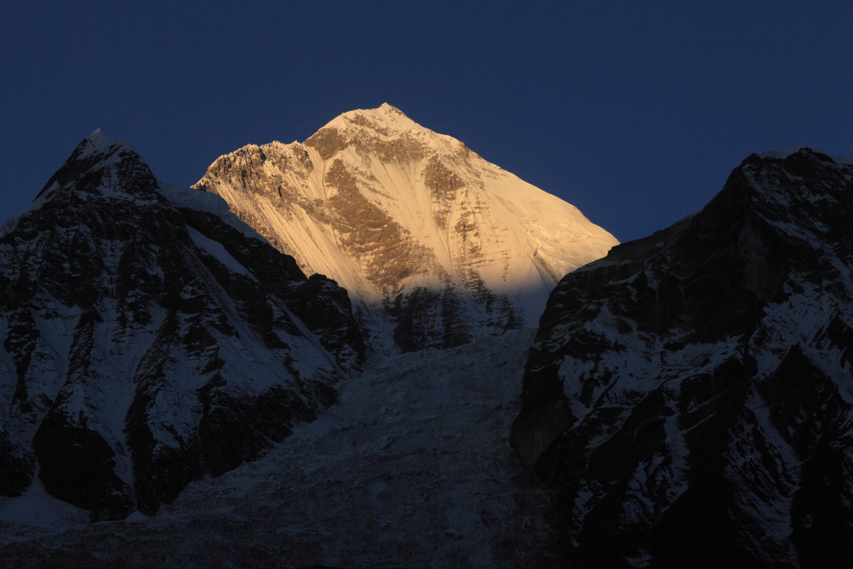
To the Muktinath Temple In December, 2013, I fulfilled my long-cherished dream to go to Himalayas. The main destinations of this journey were the Jomson trek, surrounded by the Himalayas, and the Muktinath Temple, a holy sanctuary for Hindu and Tibetan Buddhist pilgrims. I flew from Bangkok, Thailand, to Kathmandu, the capital of Napal. Then, the following day, I took another plane to Pokhara (200 kilometers west of Kathmandu), and a small plane from Pokhara to Jomson, the valley at the foot of mountains as tall as 8,000 meters high. It’s about a 2,700 meter elevation. The end of the journey, the Muktinath Temple, is at a height of 3,800 meters above sea level. If you climb too high too quickly, you will get altitude sickness. It does not just give you a high-altitude headache. Serious altitude sickness will cause death. Therefore, in order to get used to the higher elevation, I stayed for two nights at the mountain lodge located in Naurikot village descending the valley. Jomson trek is the path that follows the Kaligandali River, which flows along a valley. It used to be a trade route between Tibet and India. ***************** There is a village named Marpha between Jomson and Naurikot. Kawaguchi Ekai Memorial house was built here. Kawaguchi Ekai was a Japanese Buddhist monk in Meiji Era. He was the first recorded Japanese person to travel to Tibet seeking Buddhist texts in Sanskrit and Tibetan. In preparation for traveling to Tibet, he stayed in the Marpha village for a while. The room he had stayed in has been preserved. ***************** The path along the Kaligandaki River is a dirt road. Going across the river on the way, you really have to have a vehicle like a jeep. Naurikot is located in an overwhelming place where you can see the Dhaulagiri at 8,167 meters (the seventh tallest peak) and Nilgiri mountains right in front of you. For adapting to high altitude, I spent for a day and a half hiking to a little lake called Sekong Lake and taking photos of the mountain view from the village. Then, the following day, I headed for the Muktinath Temple, the final destination of this journey, through the Jomson trek. The magnificent mountains on both sides were more grandiose than any other scenery I had ever seen, and in this place, I could feel the energy of the earth in my bones. It was December, so there were not many green plants to see. There were only evergreens, no flowers. It was entirely the bleak and desolate earth. The road turns east at a settlement called Kagbeni, and from the road along the river to higher altitude we made our way to the Muktinath Temple, at 3,798 meters, located on the side of a mountain. The stunning sights up to this point were really overwhelming. The large-scale, winding stratification, beyond my imagination, made you clear that this land the highest peak in the world, was once an ocean floor. This was the land that was sutured together when the Eurasian and Indian Continents collided with each other. You can see the high mountains of the Kingdom of Mustang dominate afar. This place, long passed the forest line, had the surroundings of a desert. However, large trees were living in the area surrounding the Muktinath Temple. This is truly a mysterious place. We chanted the Heart Sutra with an accompanying monk before heading back. ***************** Although there are many images of the Himalayas on TV and in books, you would be overwhelmed by the sheer scale of the mountains once you are actually on site. At first, I felt awkward about how to shoot this vast and mighty wild landscape. How many photographers have taken photos of this area? I couldn’t come up with an idea how I could possibly shoot representative photos. Then, I started to realize that when you stand in this place, in front of great landscape, oneself begin to seem insignificant, rubbish thing. Just like I have always taught my students, I have come around to the idea that you should not play the eccentric artist, do accept the way it is, and that you take a photo with openness and respect. Even if your shots seem to be something you might have seen somewhere before, it does not matter. It is totally pointless to try to shoot differently from others in this great landscape. The most important thing in landscape photography is “to go to the place, and to stand on site.” As a landscape photographer, being able to stand in front of such magnificent scenery itself means so much to me. And by being here, returning to the basics of photography, having taking a photo amiably and simply is very significant to my photographer’s life. I was able to return to the original point of the landscape photography in the Himalayas. Photos at this place will be my ground zero. 2013年12月、長年の念願だったネパールに行ってきました。 メインの目的地は、 タイのバンコクから、飛行機で首都のカトマンズに入り、 ここは、標高約2700m。 一気に登ると高山病になってしまいます。 なので、高地順応をするために、 ジョムソン街道というのは、 ***************** ジョムソンとナウルコッド村の間には、 河口慧海という人は、明治時代の僧侶で、 ***************** カリ・ガンダキ川沿いの道は、 ナウルコッド村は、世界で7番目に高い 高地に体を慣らすために、 そして、その翌日、 両側に見える壮大な山々は、 また、12月なので、緑色の植物は、針葉樹くらいで、 途中、カグベニという集落から、 そこまでの絶景は、圧巻でした。 この場所は、森林限界をとっくに過ぎて、 本当に不思議な場所です。 ***************** ヒマラヤの映像なんて、 この広大で巨大な大自然の風景を、 これまで、いったいどれだけの写真家が どのように撮っても、 でも、この地に立ったら、 私が、普段から生徒さんたちにお教えしているように、 たとえそれが、どこかで見た事がある写真と同じだったとしても構わない、 風景写真で、最も大切なことは、 風景写真家として、 このヒマラヤの地で、風景写真の原点に 私にとっては、ここでの写真が、 |
コメントを残す